OVERVIEW OF MOUNT KILIMANJARO CLIMBING SAFARI
TANZANIA SAFARIS – Mount Kilimanjaro Climbing Safaris
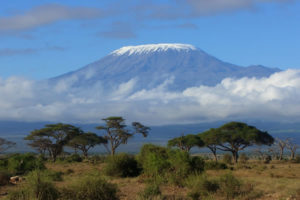
Africa’s highest mountain, Mount Kilimanjaro stands on featureless part of the East African plateau, on the Tanzanian side of the Kenya border near Moshi, side by side with the smaller Mount Meru. These mountains are extinct volcanoes, with Kilimanjaro actually being the agglomeration of three distinct volcanoes, Kibo (5896m/ 19,340 ft), Mwenzi (5,149 / 16,896 ft) and Shira (3,962m / 13,000 ft). whose violent creation is geologically associated with the creation of the Great Rift Valley, 100km to the West.
The East African mountains have created a micro-climate around themselves and the rain-shadow created to their Southand East supplies the beautiful and superbly fertile land in which the towns of Moshi and Arusha are situated, full of banana groves and coffee plantations. Kilimanjaro National Park comprises all of the mountain above the tree line and six forest corridors that stretch through the forest belt.
Origin of the name ‘Kilimanjaro’, hence Mount Kilimanjaro
There are many explanations for how the Mount Kilimanjaro got its name and no one can agree what is the truth. “Mountain of Greatness”, Mountain of Whiteness”, “Mountain of Caravans”, are all names derived from the Swahili and Chagga dialects.
From what we little know on the subject, it is thought it might have something to do with the Swahili word ‘kilima’, which means ‘top of the hill’. There is also a claim that the word “kilemakyaro” exists in the Chagga language, meaning “impossible journey”. But the truth is that no one really knows and is a good discussion point of where the name Mount Kilimanjaro came from..
Mount Kilimanjaro History
In the second century AD, Ptolemy, the Greek astronomer and cartographer, wrote of mysterious lands to the south of modern day Somalia that contained “man-eating barbarians” and a “great snow mountain”. This knowledge he must have gained from the Phoenicians, who had circumnavigated Africa by this date. Ptolemy’s account stands as the first documented reports of Africa’s highest mountain, Kilimanjaro.
The next thousand years, however, brings no mention of this great African mountain – Kilimanjaro. As the coast of East Africa rose in prominence as a trading route after the establishment of Arab rule in the sixth century, the main hub of activity centered around the island of Zanzibar and the immediate mainland known at the time as Zinj. The Arabs had at their disposal, an almost unlimited supply of ivory, gold rhinoceros horn and a far more lucrative and mobile commodity, slaves. The great slave caravans that ventured far into the interior would have passed close by to the mountain to collect water from the permanent streams but it was the Chinese traders of the twelfth century that were next to record observations of a great mountain west of Zanzibar.
Kilimanjaro was to remain a mountain of myth and superstition throughout the centuries – one of the great secrets of interior of ‘the dark continent’. It was the desire to find the source of the Nile that drove British explorers and geographers to first head inland towards the mysterious mountain around 1840 onwards. Up until then Kilimanjaro had been tall tale told by the Arab traders of Zanzibar. No one really believed that there was a snow-capped mountain on the equator.
On 16th October 1847, Rebmann a missionary, with the help of eight tribesmen and Bwana Kheri, a caravan leader, set off for the mountain of Kasigau, where they hoped to establish the first of mission posts. The journey went well and they returned to Mombasa on the 27th of the same month. Along the way they had heard the stories of the great mountain “Kilimansharo”, whose head was above the clouds and “topped with silver”, around whose feet lived the mountain’s people, the fearsome Jagga (now Chagga). Krapf immediately sought permission from the governor of Mombasa for an expedition to Jagga. His official reason was to find areas suitable for mission stations, but the legendary mountain was becoming of increasing interest to the two missionaries. Disregarding warnings about the ‘spirits of the mountain’, on the 27th April 1848, Rebmann and Bwana Kheri set off for Jagga and within just two weeks was standing on the great steppe of East Africa within sight of Kilimanjaro … the first European to set eyes on the mountain. There really were snowfields on the African equator. In April 1849, Rebmann’s observations were published in the Church Missionary Intelligenciers and although not properly substantiated until twelve years later, it remains the first confirmed report of Mount Kilimanjaro.
The first of Mount Kilimanjaro ascent in 1889
In 1887, Professor Hans Meyer, a German geographer, made his first attempt upon the summit of Kibo. Accompanied by Baron Von Eberstein, Meyer was eventually defeated by a combination of thick snow, 30m ice walls and his partner’s altitude sickness.
After an aborted expedition in 1888, Meyer returned the following year accompanied by the famous Alpinist, Ludwig Purtscheller and a well organised support group determined to scale the peak. The climbers came prepared with state of the art equipment and established a base camp on the moorland from where porters ferried fresh supplies of food from Marangu. Daunted by the precipitous ice cliffs of the northern crater rim and the extensive ice flows to the south, the two climbers agreed that the best chance of success lay by tackling the less severe incline of the south eastern slope of the Kilimanjaro mountain. From their advance camp at 4300m the two climbers set off at 01.00hrs and reached the lower slopes of the glacier at about 10.00hrs.
Although the glacier was not as steep or high as the walls encountered on Meyer’s previous attempt, its incline never went below 35 degrees and ice steps had to be cut. Progress was slow but after 2 hours the men reached the upper limits of the glacier where the incline decreased. A further 2 hours of painful trekking through waist high snow and over deep weathered ice grooves found the climbers at the rim of the crater with the summit in sight. However time and strength were running out and the summit was still another 150m above them, so they returned to advance camp to try again after three days. This time the route was clearly marked and the previously cut ice steps had held their shape. The rim of the Mount Kilimanjaro was reached in 6 hours and at exactly 10.30hrs Meyer became the first recorded person to set foot on the highest point in Africa.
Although Meyer and Purtscheller laid the trail for further ascents on Kilimanjaro, there was not an instant queue of would-be climbers. It wasn’t until 1912, over 20 years later, when a path from Marangu was established and the first huts at Mandera and Horombo were built by Dr. E Forster for the newly formed German Kilimanjaro Mountain Club, that activity began in earnest.
Mount Kilimanjaro was born of the catastrophic movements in the Earth’s crust that created the Great Rift Valley that runs from the Red Sea through Tanzania to Southern Africa. Around 25 million years ago East Africa was a huge flat plain that buckled and ruptured after the African and Eurasian Continental Plates rebounded off each other causing huge rifting and weak spots in the thinning crust that led to the formation of many volcanoes in the region. Where the original valley was deepest, the volcanic activity was greatest eventually forming the huge volcanoes of Ngorongoro Crater on the Rift itself and a string of volcanoes to the East including Meru, Kenya and Kilimanjaro. Ecology Mount Kilimanjaro has five major zones and the activity within each of these is controlled by the five factors of altitude, rainfall, temperature, flora and fauna. Each zone occupies an area approximately 1000m in altitude and is subject to a corresponding decrease in rainfall, temperature and life from the forest upwards.
Mount Kilimanjaro is a perfectly shaped volcano still active rising sheer from the plains. At 5895m it is the highest in Africa and is snow capped. Mount Kilimanjaro can be climbed any time of the year but there is usually a lot more rain during April, May and November. At the lower levels, you will pass through cultivated farmlands rising through tropical rain forest onto alpine meadows and finally the barren landscape leading to the snow and ice capped summit. The lower levels also offer the chance to view a wide variety of animals, birds and fauna in their natural habitat.
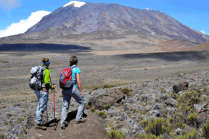
There are five major Mount Kilimanjaro Climbing routes through the forest and moor land areas before joining the south circuit path between 3500m and 4500m they are; Kilimanjaro Machame route, Mount Kilimanjaro Marangu route, Kilimanjaro Climbing Lemosho Route, Kilimanjaro Rongai Route and Climbing Kilimanjaro Umbwe route.
From Mount Kilimanjaro south circuit path various walking (trekking), scrambling, and technical climbing trails take you the last 1200m or so to the summit. Most people however take the final leg of the Kilimanjaro Marangu route unless you are a technical climber in which case the summit may be reached via Rebman glacier, decken glacier or heim glacier amongst others. The final trekking Kilimanjaro ascent to the summit starts normally at about 2.00 am from Kibo hut so that it is reached before dawn to watch the sunrise and gaze out over the vast expanses of African bush land from the roof of Africa – Mount Kilimanjaro.
Mount Kilimanjaro National Park is the area above 2,700 meters on the mountain. Kilimanjaro National Park includes the moorland and highland zones, Shira Plateau, Kibo and Mawenzi peaks. In addition, the Kilimanjaro Park has six corridors or rights of way through the Kilimanjaro Forest Reserve. The Forest Reserve, which is also a Game Reserve, was established in 1921; the Park was established in 1973 and officially opened in 1977.
Mount Kilimanjaro facts and figures
*The highest peak in Africa
*The highest freestanding peak in the world
*The highest ‘walkable’ mountain in the world
Kilimanjaro Protection
*1921 : forest reserve established
*1973 : park established
*Park HQ Opened : 1977 (by President Nyerere)
*Unesco World Heritage : 1989
Mount Kilimanjaro location
*Northern Tanzania : East Africa
*2 50′ / 3 20’S : 37 00 / 37 35’E
Kilimanjaro areas
*Park : 756 sq km / 75,353ha
*Forest reserve : 929 sq km / 92,906ha
Mount Kilimanjaro altitudes
*Marangu Gate : 1,830m
Kilimanjaro Summit : 5,895m -25C to 10C
Kilimanjaro rainfall at altitudes
*Forest Belt : 1800m : 2300mm
*Mandara Hut : 2740m : 1300mm
*Horobo Hut : 3718m: 525mm
*Kibo Hut : 4630m : 200mm
Kilimanjaro temperatures
*Generally falls 1C with every 200m increase in altitude
*Marangu Gate : 10C to 30C
Mount Kenya Mount Kilimanjaro
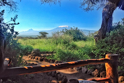
The Lemosho Route is an un spoilt, remote, little used and beautiful way up to the Shira Plateau. It can either be used to gain the Western Breach route or followed by the Kibo South Circuit to ascend by the easier Barafu Route. The route is one of the few where groups may be accompanied on the first day by an armed ranger, as the forests around the Lemosho Glades are rich in buffalo, elephant and other big game animals.
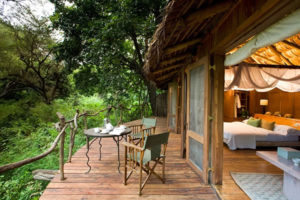
Day 1: Arrival – Moshi
On arrival at Kilimanjaro Airport, met and assisted. Transfer to Keys Annex Hotel in Moshi for an overnight rest on bed and breakfast in readiness for the next day’s hit to Kilimanjaro.
Day 2: Londorossi Gate (2100m) – Mti Mkubwa camp (2750m)
Hiking time: 3 hours | Habitat: Montane forest
Your day starts early with a briefing, followed by breakfast and a drive to Londorossi Park Gate (2100m). The guides and porters prepare and pack the supplies and your equipment in the village. You will receive a lunch pack and you can also buy mineral water in the village. From here a forest track requiring a 4WD vehicle leads to Lemosho Glades (2100m, 11km, 45 minutes). You will have a lunch stop about half way and will reach the Machame camping area in the late afternoon. Walk along forest trails to Mti Mkubwa (big tree) campsite, (2750m, 3 hours). Your porters (arriving at the camp site long before you) will have your tent set up on your arrival. In the evening the porters will boil drinking and washing water and the cook will prepare dinner, before you retire to your tent for the night. Night temperatures can already drop to freezing point at this campsite, B,L,D.
Day 3: Mti Mkubwa camp (2750m) – Shira 2 camp (3840m)
Hiking time: 6.5 hours | Habitat: Moorland
You rise early at Mti Mkubwa camp and, after breakfast, you climb an hour or so to the top of the forest and then the trail gradually steepens and enters the giant heather moorland zone. Several streams are crossed. A gentle walk across the plateau leads to Shira 2-camp on moorland meadows next to a stream (3840m). By now you will be able to see, in an easterly direction, the Western Breach with its stunning glaciers. The porters will boil drinking and washing water, before serving dinner. The night at this exposed camp will even be colder than the previous night, with temperatures dropping to well below freezing. Enjoy dinner and overnight, B,L,D.
Day 4: Shira (3840m)-Lava Tower (4630m) – Barranco camp (3950m)
Hiking time: 7 hours | Distance: About 15 km’s | Habitat: Semi desert
The route now turns east into a semi desert and rocky landscape surrounding Lava Tower, where you reach an altitude of 4630m after about a 5 hours walk. Lunch is served in a designated area before ascending the rocky scree path to Lava Tower (4630m). Definitely the toughest day so far. It is normally around this point, where for the first time, some climbers will start to feel symptoms of breathlessness, irritability and headaches. After lunch you descent again by almost 680m to the Barranco camping area and after reaching the high altitude of 4600m at Lava Tower, the true acclimatisation benefit of this day becomes clear. This descent to Barranco camp takes about 2 hours and offers great opportunities to take some beautiful photographs of the Western Breach and Breach Wall. The camp is situated in a valley below the Breach and Great Barranco Wall, which should provide you with a memorable sunset while you wait for your dinner, B,L,D.
Day 5: Barranco camp (3950m) – Barafu camp (4550m)
Hiking time: 7 hours | Distance: About 13 km’s | Habitat: Alpine desert
After spending a night at the Great Barranco Wall (a very imposing sight at first), you make your way up this awesome looking obstacle, which in the end normally turns out to be easier than anticipated. Topping out just below the Heim Glacier, you now appreciate just how beautiful Kilimanjaro really is. The route then heads down through the Karanga Valley over intervening ridges and valleys, and then joins up with the Mweka route. This is the preferred route down from the summit, so remember it. Turn left up the ridge and after another hour or so, you reach Barafu Hut. The last water stop on the route is the Karanga Valley, as there is no water at Barafu camp. Barafu is the Swahili word for “ice” and it is a bleak and inhospitable camping area to spend the night. Totally exposed to the ever-present gales the tents are pitched on a narrow, stony, and dangerous ridge. Make sure that you familiarise yourself with the terrain before dark to avoid any accidents. The summit is now a further 1345m up and you will make the final ascent the same night. Prepare your equipment, ski stick and thermal clothing for your summit attempt. This should include the replacement of your headlamp and camera batteries and make sure you have a spare set available as well. To prevent freezing it will be wise to carry your water in a thermal flask. Go to bed at round about 19h00 and try to get some precious rest and sleep, B,L,D.
Day 6: SUMMIT ATTEMPT, Barafu camp (4550m)-Uhuru Peak (5895m)-Mweka (3100m)
Hiking time: 8 hours to reach Uhuru Peak 7/8 hours to descend to Mweka | Distance: About 7 km’s ascent – 23 km’s descent | Habitat: Stone scree and ice-capped summit
You will rise around 23h30, and after some tea and biscuits you shuffle off into the night. You will head in a northwesterly direction and ascend through heavy scree towards Stella Point on the crater rim. This 6-hour walk to Stella point is for many climbers, mentally and physically the most challenging on the route. At Stella Point (5685m) you will stop for a short rest and will be rewarded with the most magnificent sunrise you are ever likely to see (weather permitting). From Stella Point you will normally encounter snow all the way on your 2-hour ascent to Uhuru Peak. The time you will spend on the summit will depend on the weather conditions. Do not stop here for too long, as it will be extremely difficult to start again due to cold and fatigue. Enjoy your accomplishment and a day to remember for the rest of your live. The walk back to Barafu from the summit, takes about 3 hours. Here you will have a well earned but short rest and collect the rest of your gear, before heading down to Mweka hut (3100m).
The route is not difficult and will take you down the rock and scree path into the moorland and eventually into the forest. The camp is situated in the upper forest and mist or rain can be expected in the late afternoon. Dinner and washing water will be prepared as well as drinking water, B,L,D.
Day 7: Mweka camp (3100m) – Mweka Gate (1980m)
Hiking time: 3 hours | Distance: About 15 km’s | Habitat: Forest
After an early and well-deserved breakfast, it is a short 3-hour and scenic hike back to the Park gate. At Mweka gate you sign your name and details in a register. This is also where successful climbers receive their summit certificates. Those climbers who reached Stella Point (5685m) are issued with green certificates and those who reached Uhuru Peak (5895m) receive gold certificates. From the Mweka Gate you will continue down into the Mweka village, normally a muddy 3 km (1 hour) hike. In the Mweka village you will be served a delicious hot lunch!! You now drive back to Moshi for a long overdue hot shower, dinner and celebrations!! Overnight in Keys Annex Hotel, B,L.
Day 8: Departure
Transfer to Kilimanjaro Airport for your flight back home or continue with your safari schedule. End of services. B
Tour Price: US$ 1,950 per person sharing. Single room supplement: US$ 80
Tour price includes:
- Transfer to and from the base of the mountain
- Lemosho route trek as itinerary depicts
- Full board accommodation whilst on the trek.
- Meal plan as detailed: B=Breakfast, L=Lunch and D=Dinner
- Accommodation at Keys Annex Hotel in Moshi for 2 nights on bed and breakfast
- Accommodation in huts on the mountain as per the itinerary
- All park entrance fees to include government taxes
- Service of an English speaking professional Mountain guide on the mountain, porters and skilled cook
- All services begin and end at Kilimanjaro Airport as per the itinerary
- Treated water on the trek
- Return airport transfers from/to Kilimanjaro Airport
- Mountain rescue fees
Price excludes:
- Tips, laundry, sleeping bags, drinks and climbing gears
- Medical evacuation, USD 30 per person value
- International flights and taxes
- Visas
- Items of a personal nature and any other extras not detailed in the above itinerary.